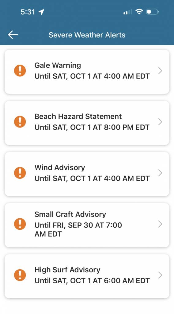
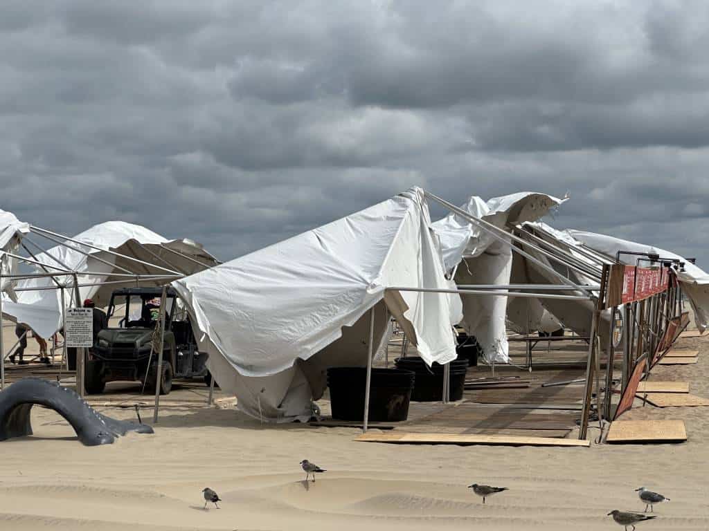
Ian has devastated Florida, he is taking aim at South Carolina and now he is threatening our region with the effects of his passing. To make it worse, we have a high pressure to our north which keeps our weather dismal throughout the weekend. The National Weather Service has issued gale warnings, high surf advisories, small craft advisories, and more. Please stay connected and up-to-date on the latest forecast for Ocean City, MD.

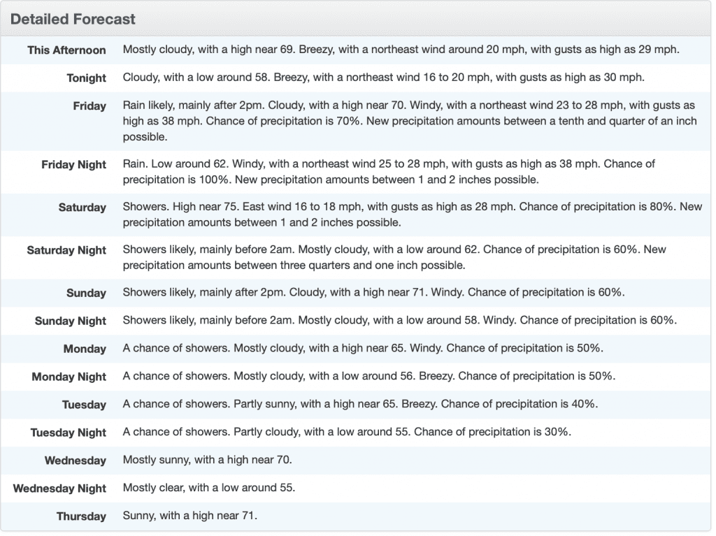
DETAILED FORECAST FROM NOAA
NATIONAL WEATHER SERVICE HAZARDOUS WEATHER OUTLOOK
Hazardous Weather Outlook
National Weather Service Wakefield VA
418 PM EDT Thu Sep 29 2022

MDZ025-302030-
Maryland Beaches-
418 PM EDT Thu Sep 29 2022

...HIGH RIP CURRENT RISK IN EFFECT THROUGH SATURDAY EVENING...
...MODERATE RIP CURRENT RISK IN EFFECT UNTIL 8 PM EDT THIS EVENING...
...BEACH HAZARDS STATEMENT IN EFFECT FROM 8 PM EDT THIS EVENING
THROUGH SATURDAY EVENING...
...WIND ADVISORY IN EFFECT FROM 8 AM FRIDAY TO 4 AM EDT SATURDAY...
...HIGH SURF ADVISORY IN EFFECT FROM 10 AM FRIDAY TO 6 AM EDT
SATURDAY...

This Hazardous Weather Outlook is for southeast Maryland.

.DAY ONE...Tonight.

Please listen to NOAA Weather Radio or go to weather.gov on the
Internet for more information about the following hazards.

   MODERATE RIP CURRENT RISK.
   HIGH RIP CURRENT RISK.
   Beach Hazards Statement.

.DAYS TWO THROUGH SEVEN...Friday through Wednesday.

Please listen to NOAA Weather Radio or go to weather.gov on the
Internet for more information about the following hazards.

   HIGH RIP CURRENT RISK.
   Beach Hazards Statement.
   Wind Advisory.
   High Surf Advisory.

.SPOTTER INFORMATION STATEMENT...

Spotter activation is not expected at this time.

$$
Beach Hazards Statement From the National Weather Service
Coastal Hazard Message
National Weather Service Wakefield VA
408 PM EDT Thu Sep 29 2022

MDZ025-300415-
/O.CON.KAKQ.SU.Y.0009.000000T0000Z-221001T1000Z/
/O.CON.KAKQ.BH.S.0008.220930T0000Z-221002T0000Z/
Maryland Beaches-
408 PM EDT Thu Sep 29 2022

...HIGH SURF ADVISORY REMAINS IN EFFECT UNTIL 6 AM EDT SATURDAY...
...BEACH HAZARDS STATEMENT REMAINS IN EFFECT FROM 8 PM EDT THIS
EVENING THROUGH SATURDAY EVENING...

* WHAT...For the High Surf Advisory, large breaking waves of 6
  to 10 feet expected in the surf zone. There is also a high
  risk of rip currents.

* WHERE...Maryland Beaches County.

* WHEN...For the High Surf Advisory, until 6 AM EDT Saturday.
  For the Beach Hazards Statement, from 8 PM EDT this evening
  through Saturday evening.

* IMPACTS...Dangerous swimming and surfing conditions and
  localized beach erosion.

PRECAUTIONARY/PREPAREDNESS ACTIONS...

Inexperienced swimmers should remain out of the water due to
dangerous surf conditions.

Remain out of the water to avoid hazardous swimming conditions.

&&

Time of high total tides are approximate to the nearest hour.

OCEAN CITY INLET MD
MLLW CATEGORIES - MINOR 4.0 FT, MODERATE 5.0 FT, MAJOR 6.0 FT
MHHW CATEGORIES - MINOR 1.5 FT, MODERATE 2.5 FT, MAJOR 3.5 FT

             TOTAL      TOTAL    DEPARTURE
 DAY/TIME    TIDE       TIDE     FROM NORM   WAVES    FLOOD
            FT MLLW    FT MHHW       FT       FT      IMPACT
 --------  ---------  ---------  ---------  -------  --------
 29/11 PM     3.0        0.5        0.6        1       NONE
 30/12 PM     4.0        1.5        1.2        1      MINOR
 30/11 PM     3.5        1.0        1.3        1       NONE
 01/01 PM     3.9        1.4        1.1        1       NONE
 02/01 AM     3.2        0.7        1.0        1       NONE

&&

$$

MRD
High Surf Advisory
Coastal Hazard Message
National Weather Service Wakefield VA
408 PM EDT Thu Sep 29 2022

MDZ025-300415-
/O.CON.KAKQ.SU.Y.0009.000000T0000Z-221001T1000Z/
/O.CON.KAKQ.BH.S.0008.220930T0000Z-221002T0000Z/
Maryland Beaches-
408 PM EDT Thu Sep 29 2022

...HIGH SURF ADVISORY REMAINS IN EFFECT UNTIL 6 AM EDT SATURDAY...
...BEACH HAZARDS STATEMENT REMAINS IN EFFECT FROM 8 PM EDT THIS
EVENING THROUGH SATURDAY EVENING...

* WHAT...For the High Surf Advisory, large breaking waves of 6
  to 10 feet expected in the surf zone. There is also a high
  risk of rip currents.

* WHERE...Maryland Beaches County.

* WHEN...For the High Surf Advisory, until 6 AM EDT Saturday.
  For the Beach Hazards Statement, from 8 PM EDT this evening
  through Saturday evening.

* IMPACTS...Dangerous swimming and surfing conditions and
  localized beach erosion.

PRECAUTIONARY/PREPAREDNESS ACTIONS...

Inexperienced swimmers should remain out of the water due to
dangerous surf conditions.

Remain out of the water to avoid hazardous swimming conditions.

&&

Time of high total tides are approximate to the nearest hour.

OCEAN CITY INLET MD
MLLW CATEGORIES - MINOR 4.0 FT, MODERATE 5.0 FT, MAJOR 6.0 FT
MHHW CATEGORIES - MINOR 1.5 FT, MODERATE 2.5 FT, MAJOR 3.5 FT

             TOTAL      TOTAL    DEPARTURE
 DAY/TIME    TIDE       TIDE     FROM NORM   WAVES    FLOOD
            FT MLLW    FT MHHW       FT       FT      IMPACT
 --------  ---------  ---------  ---------  -------  --------
 29/11 PM     3.0        0.5        0.6        1       NONE
 30/12 PM     4.0        1.5        1.2        1      MINOR
 30/11 PM     3.5        1.0        1.3        1       NONE
 01/01 PM     3.9        1.4        1.1        1       NONE
 02/01 AM     3.2        0.7        1.0        1       NONE

&&

$$

MRD
Wind Advisory
URGENT - WEATHER MESSAGE
National Weather Service Wakefield VA
341 PM EDT Thu Sep 29 2022

MDZ025-VAZ077-078-084>086-099-100-300345-
/O.NEW.KAKQ.WI.Y.0010.220930T1200Z-221001T0800Z/
Maryland Beaches-Northumberland-Lancaster-Gloucester-Middlesex-
Mathews-Accomack-Northampton-
Including the cities of Ocean City, Lewisetta, Alfonso,
Beanes Corner, Brook Vale, Kilmarnock, Lancaster, Lively, Regina,
Achilles, Glass, Gloucester Point, Maryus, Naxera, Ordinary,
Severn, Grafton, Harmony Village, Church View, Cooper, Healys,
Jamaica, Nesting, Bavon, New Point, New Point Comfort, Peary,
Chincoteague, Wallops Island, Melfa, Exmore, Cape Charles,
Cheapside, Fishermans Island, Kiptopeke, Kiptopeke State Park,
and Plantation
341 PM EDT Thu Sep 29 2022

...WIND ADVISORY IN EFFECT FROM 8 AM FRIDAY TO 4 AM EDT
SATURDAY...

* WHAT...Northeast winds 20 to 30 mph with gusts up to 50 mph
  expected.

* WHERE...In Maryland, Maryland Beaches County. In Virginia,
  Northumberland, Lancaster, Gloucester, Middlesex, Mathews,
  Accomack and Northampton Counties.

* WHEN...From 8 AM Friday to 4 AM EDT Saturday.

* IMPACTS...Gusty winds could blow around unsecured objects.
  Tree limbs could be blown down and a few power outages may
  result.

PRECAUTIONARY/PREPAREDNESS ACTIONS...

Use extra caution when driving, especially if operating a high
profile vehicle. Secure outdoor objects.

&&

$$

For more information from the National Weather Service visit
https://weather.gov/akq
NOAA National Weather Service
1325 East West Highway
Silver Spring, MD 20910
E-mail: w-nws.webmaster@noaa.gov